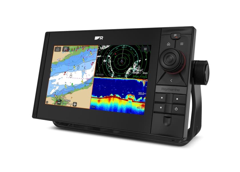
GO9 XSE/ Touch/ with ForwardScan
Transducer
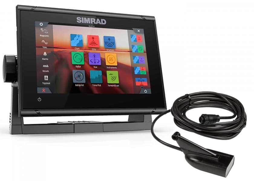
SIMRAD
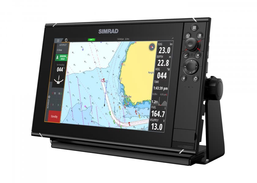
The Simrad GO9 XSE chartplotter navigation display is a perfect way to expand the capabilities of sportboats, cruisers, and smaller center consoles with plug-and-play support for Simrad Broadband Radar™ and Halo™ Pulse Compression radar systems. Behind a super-bright, multi-touch widescreen display lies a built-in GPS receiver, GoFree® Wi-Fi, and industry standard NMEA 2000® connectivity. Connect with smartphones and tablets, control your onboard sound system, monitor engine data, and choose from an array of built-in sonar technology to cruise with confidence and find fish like a pro. Supplied with ForwardScan transducer.
Key features:
Easy to use multi-touch interface
Full-featured chartplotter with widest available cartography support (Insight, Navionics, CMAP)
Radar display for Simrad Broadband 3G™/4G™ and Halo™ Pulse Compression radar systems
Includes worldwide basemap
Plan smarter with TripIntel™ technology
Support for Navionics Autorouting and C-MAP Easy Routing
9-inch flush or bracket mount display
Widescreen with bright LED backlight
High-speed 10 Hz GPS receiver
Built-in Broadband Sounder™, CHIRP sonar, StructureScan® HD imaging or ForwardScan™ sonar support (transducer required)
Built-in GoFree™ Wi-Fi
Dual microSD card slots
Compatible with the Simrad WM-3 SiriusXM satellite weather module (North America only)
NMEA 2000® compatible
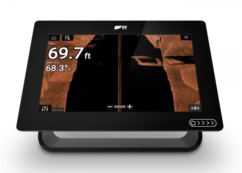
Easy to Use Multi-Touch Display
The GO9 XSE offers true ease of use with intuitive touchscreen controls that smartphone and tablet users will find instantly familiar. Tap to create or select waypoints, pinch to zoom, or tap and drag to pan smoothly across charts. Simple home screen and menu layouts make all functions quickly accessible, with large and clearly-captioned icons that are easy to recognise and tap.
Chartplotter Navigation & Waypoint Management
The GO9 XSE is a full-featured chartplotter, with support for the widest available range of cartography options including C-MAP® MAX-N, Navionics®, Insight®, Insight Genesis®, and NV Digital® Charts. Navigate confidently to destinations near and far, with the flexibility to choose charts that best fit your needs and location. Set and record those destinations easily with simple waypoint mangement: mark waypoints with a touch, and assign meaningful names that make it easy to look up your desired destination whether you’ve mapped out ten places or a thousand.
Expand Your View with a Simrad Radar Device
The Simrad GO9 XSE is a full-featured radar display with plug-and-play connectivity to Simrad Broadband 3G™, Broadband 4G™, and Halo™ Pulse Compression radar systems. Cruise confidently through crowded harbours, navigate safely in poor visibility, keep an eye on distant weather cells, and find flocks of feeding birds that hint at good fishing spots. Automatic tuning helps to provide a clear radar picture in any conditions, while radar overlay combines radar data with navigational charts for an easy-to-interpret view of your surroundings.
Fully Customisable Interface
The Simrad GO9 XSE is fully customisable to suit your vessel and your favourite on-water activities – from power boating, to fishing, to water sports. Customise your home screen with shortcuts to the features you use most, and personalise it with your choice of wallpaper. Adjustable split-screen views and customisable panel layouts let you see everything you need on-screen at once, whatever your activity.
Plan Smarter with TripIntel™ Technology
Designed for power boaters, TripIntel technology tracks and displays the key information you need to plan safe and enjoyable days on the water. Make smart decisions with fuel range overlaid on charts, easy access to current and future tide levels, and a detailed history of your previous trips including the route you took and how your boat performed.
Easier Navigation with Automatic Routing
Automatic routing brings the convenience of in-car navigation to boating, helping you to plot a route and get underway with less delay. Simply select a destination, and your GO XSE display will suggest the shortest, safest route taking into consideration the draught and dimensions of your vessel. This feature is available with Navionics+ or Navionics Platinum charts (Navionics Autorouting), and with C-MAP MAX-N+ charts (C-MAP Easy Routing).
Built-in 10 Hz GPS receiver*
With a high-speed GPS receiver updating your position ten times every second, the Simrad GO9 XSE is ideal for use aboard fast-moving RIBs and powerboats. Watch your boat’s movement tracked smoothly, accurately, and in real-time, without ‘jumping’ from point to point on the display.
Cruise Charting View
Designed with power boating in mind, the Simrad GO9 XSE offers a unique Cruise Charting page that brings together crucial navigation data and charts in one easily readable display. Choose the information most relevant to your crusing style and on-water activities with the ability to edit on-screen data items.
NMEA 2000® Engine Monitoring & Instrumentation
The Simrad GO9 XSE connects to any NMEA 2000®-capable equipment aboard your vessel including outboard and inboard engines; fuel level and flow meters; speed, heading, and water temperature sensors; and much more. Create your own custom digital instrument displays, bringing a wealth of information to even the most crowded dash while keeping a clean look with as few gauges as possible.
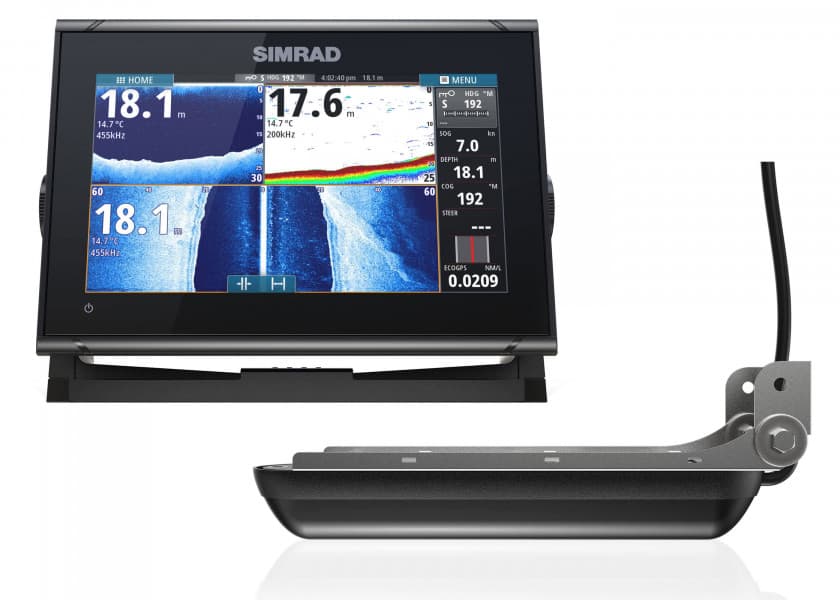
Watch Your Depth with Built-in Sonar
Knowing the true depth beneath your hull can help you enjoy your time on the water with fewer worries, and makes it easier to locate suitable anchorages in unfamiliar waters. With built-in sonar, just add a suitable sonar transducer for accurate, real-time depth tracking. A scrollable depth history view lets you track back and easily set waypoints for promising anchorages, while StructureScan Imaging™ combines DownScan and SideScan sonar to offer a picture-like view of the bottom beneath your vessel.
Cruise Confidently with ForwardScan™ Sonar
Using an optional ForwardScan transducer, this forward-looking sonar technology provides a clear two-dimensional image of the bottom in front of your vessel, allowing you to navigate shallow or poorly-charted waters with confidence. With real-time updates and a forward-looking view of up to eight times your current depth, ForwardScan lets you relax and enjoy a safer day on the water.
Find fish with CHIRP & StructureScan® HD sidescan imaging
Whether fishing is your life or just a casual hobby, any fishing trip will benefit from the extensive array of built-in sonar technology on the Simrad GO9 XSE. Add a suitable transducer, available separately or bundled with your display, and the GO9 XSE works as a powerful fishfinder with CHIRP-enabled broadband sonar for clear detection of fish throughout the water column. With an optional HDI or TotalScan transducer, the GO9 XSE also offers StructureScan HD sidescan imaging for a picture-like view of fish-holding structure beneath and around your boat.
Simrad SonicHub®2 & Bluetooth® Audio Integration
If you’re not at home on the water without a good soundtrack, the Simrad SonicHub®2 marine audio system is the perfect companion to a GO9 XSE display. Stream music from Bluetooth® connected tablets, smartphones, and other mobile devices, play MP3 files from a USB flash drive, or listen to the SonicHub 2’s built-in AM/FM radio. SonicHub 2 brings complete control of your audio entertainment to your GO9 XSE display, eliminating the need for a separate stereo head-unit and letting you listen to your music, your way.
GoFree™ cloud enabled with Built-in Wi-Fi
With Wi-Fi built in, the Simrad GO9 XSE provides direct access to GoFree cloud services including easy wireless map downloads, software updates, and more. Whether hooked up to your home Wi-Fi with your boat trailered in the driveway, logged in to your marina’s Wi-Fi, or tethered to your smartphone out on the lake, you can access GoFree cloud services anywhere you have an internet connection. On the water, GoFree connects the Simrad GO9 XSE to your mobile devices, mirroring your display’s screen on your smartphone or giving you full remote control from your tablet with the free GoFree Controller app.
SiriusXM Weather Integration
The Simrad GO9 XSE is the only GO Series display compatible with SiriusXM Marine satellite weather, via the optional WM-3 expansion module, for real-time access to weather information right on your display. With onboard access to weather radar, surface buoy reports, NOAA Marine Zone forecasts and more, you can check out the conditions offshore before you even leave the dock. SiriusXM Marine is a subscription service, exclusively available within North America.
* Built-in GPS receiver works in any bracket-mount installation, and when flush-mounted with most fibreglass hulls. When flush-mounted in a metal hulled vessel, an external GPS receiver such as the Simrad GS25 may be required.
Technical data:
Display Type
WVGA Colour TFT-LCD
Display Size
9-inch Widescreen
Display Resolution
800 x 480
Backlighting Levels
LED / 1200 nits
Other Features
Waypoint Storage: 10,000 points total combined waypoints / route points
Languages
Standard Language Pack, Asian Language Pack, Eastern European Language Pack, Russia/Ukraine Language Pack, Middle Eastern Language Pack
Memory Card Capable
Chart card slot: microSD
GPS Antenna Type
Built-in 10 Hz GPS
Operating Temperature
15 °C to +55 °C (5 °F to 131 °F)
Waterproof Rating
IPX7
Width
243 mm / 9.56 in
Depth
83 mm / 3.26 in
Height
171 mm / 6.71 in
Weight
1.32 kg / 2.91 lb
Power Consumption
12 W @ 13.8 V
Power Supply
12 V DC
NMEA2000 Pending Certification
1 port
Supplied with ForwardScan transducer
So you know what lies ahead!
2D sonar images of the ground beneath your boat
Simrad ForwardScan Technology
Forward Scan provides you with a 2D sonar image of the sea bed in front of your boat. In shallow, unknown or poorly charted waters ForwardScan will help you navigate safely and avoid grounding. It is also a useful aid when searching a safe anchorage that still offers enough space for free-swinging even with wind direction changes.
The forward scan sensor works with 180 kHz, thus reducing perfectly the common interference of traditional 200 kHz sonars. The maximum preview distance is roughly the 8-fold distance of your current depth. For example: If you are currently cruising in waters of 5m depth, you can preview the deep waters that lie up to 40m ahead. At a speed of 3 knots this distance will be passed in around 30 seconds. Accordingly, the Simrad ForwardScan sonar is no module made for high speeds, but a navigational aid for maneuvers at low speed.
Integration in MFD-Systems with Simrad NSS evo2/NSO evo2
Forward Scan can be connected quickly and easily via the StructureScan Port evo2 to any Simrad NSS multifunction display - you do not need any additional hardware. For NSO evo2-module systems or NSS evo2 systems that are already using the Structure Scan, ForwardScan can be connected via the optional Simrad / Lowrance SonarHub sounder module.
Bottom tracing in a coloured display
The bottom tracing in a coloured display provides a graphical 2D representation of the ground ahead of your boat that is easily understandable without further explanations. So you can make your navigation decisions quickly and effectively.
(Left picture: bottom tracing in color represents data points, right picture: only bottom tracing represented in color)
Course line display
The course line display combines ForwardScan depth data with the course line displayed on the navigation page of your Simrad MFD. The line is displayed in colored segments, depending on whether it is deep, medium or shallow water, whereby you can adjust your boat's depth levels accordingly.
Easy installation
Thanks to the 50.8 mm (2") through-hull fittings from stainless steel the ForwardScan transducer can be installed on almost every boat. The implementation also works for 25.4 mm (1") thick side walls with keel angle 12° or 19 mm (3/4") thick side panels suitable with 20° keel angle.
Features
Discover the features that make this product stand out. From technical details to special
functions – we’ve summarized all the key information for you.
Display size
9 Inch
Operating mode
Touch screen
NMEA2000
NMEA0183
No
WiFi
Bluetooth
Radar capable
Yes
Tablet control
Sonar module
Yes
Viewing angle
Forwards
With transducer